


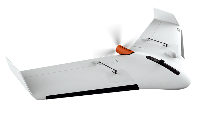
Delair UX11 C6 EASA Certification
- A professional fixed-wing drone compatible with PPK/RTK for high-precision photogrammetry, certified with C6 EASA, ready for STS-02 flights and training.
Delair UX11
Professional Mapping Drone with C6 EASA Certification
The Delair UX11 is a state-of-the-art mapping drone that combines unmatched ease of use, efficiency, and high-quality aerial data. With its C6 EASA certification, it is fully compliant with European regulations, allowing for STS-02 flights and training.
Map and Digitize Large Areas with High Accuracy
Ease of Use
High Productivity
High-Quality Data
The Delair UX11 is the ideal drone solution for precise and easy mapping. It provides integrated functionalities before, during, and after flight, including a built-in camera with a global shutter, a GNSS sensor with centimeter precision, and a PPK function that enables survey-grade results. The drone supports 2.4 GHz wireless and 3G/4G cellular connectivity, making it usable anywhere. Its operational parameters (flight time up to 80 minutes, covering over 121 hectares at an altitude of 122 meters) significantly reduce the total cost of ownership compared to other mapping and survey options.
Key Features of UX11
-
Fast Mapping of Large Areas
A single operator can map 9.6 km2 with a ground pixel size of 1.7 cm in an 8-hour workday flying at 122 m AGL. A high-quality professional camera and optional PPK activation provide survey-grade accuracy. With UX11, you don’t have to sacrifice resolution for productivity—you can have both.
-
Long-Range Communication for BVLOS
The dual communication system includes a standard 2.4 GHz WiFi radio link and cellular 3G connectivity (also compatible with 4G) for virtually unlimited range.
-
Precise and Steep Takeoffs and Landings (BTOL)
Delair’s landing maneuver is inspired by birds—just before touchdown, the aircraft executes a deep stall with a high angle of attack, slowing down rapidly to minimize ground friction and ensure a precise, smooth landing. Takeoffs and landings occur at about a 30° angle, allowing operation in confined spaces.
-
Top-Tier Performance
Absolute positioning accuracy using PPK (optional) is up to 1 cm. Flight time reaches up to 59 minutes in optimal conditions. With 3G/4G connectivity, range is virtually unlimited. The ground resolution at 122 m altitude is just 1.7 cm.
-
Delair Flight Deck
An intuitive Android-based application for flight planning and monitoring. It features pre-flight checklists, No Fly Zone markings, a modern user interface, real-time telemetry monitoring, and live image previews to ensure data quality during acquisition.
-
C6 EASA Certification Compliance
Enables flights and training under STS-02 in accordance with the latest European Union regulations.
Boost Mapping Productivity with a Fixed-Wing Drone
Long Flight Time and Range for Large Areas
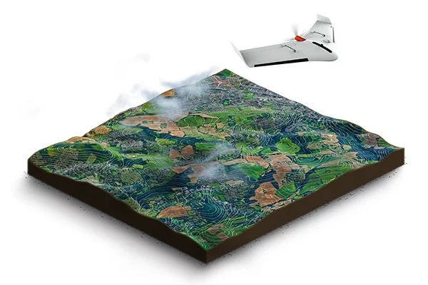
With an 80-minute flight time and up to 53 km range, the UX11 offers unmatched productivity. You can map 120 hectares at 120 m altitude with a 1.7 cm GSD in a single flight.
Dual Communication Systems for Greater Range
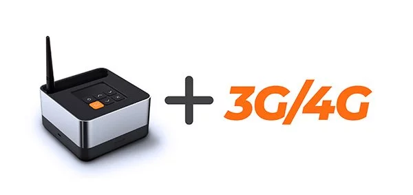
The UX11 is always connected via both cellular (3G/4G) and radio (2.4 GHz Delair Link). It is one of the few drones ready for BVLOS flights. Delair Link provides a range of up to 6.4 km in FCC regions and 3.2 km in CE regions.
The Easiest to Use Professional Mapping Drone
1. Convenient and Easy to Transport
The UX11 is lightweight (only 1.6 kg) and easy to carry. It includes a compact transport bag (43 x 36 x 80 cm), which can be carried as a backpack (13 kg).
2. Quick and Easy Setup
The UX11 can be quickly set up in the field. Simply connect two wings, and the drone is ready to fly. Assembly time is less than 5 minutes.
3. Easy Flight Control via Tablet
Plan your mission on a tablet using Delair Flight Deck software. You can control takeoff, landing, flight direction, and perform pre-flight checks.
4. Easy and Fully Automated Flight
Takeoff is manual. Flight and landing are fully automated thanks to Delair Flight Deck software.
5. Precise and Automatic Landing
The UX11 lands with high precision using reverse thrust and a ground sensor. It can land in small areas with a 30° descent angle.
6. Streamlined Data Management
Delair After Flight software automatically filters, selects, and processes raw data, enabling export to formats compatible with photogrammetry software.
7. Convenient and Easy to Transport
The UX11 is lightweight (only 1.6 kg) and easy to carry. It includes a compact transport bag (43 x 36 x 80 cm), which can be carried as a backpack (13 kg).
Real-Time Image Quality Control
You can monitor camera settings and image quality during flight thanks to real-time radio connectivity with the ground control station. Real-time image quality reports eliminate the guesswork of whether your data meets photogrammetric requirements.
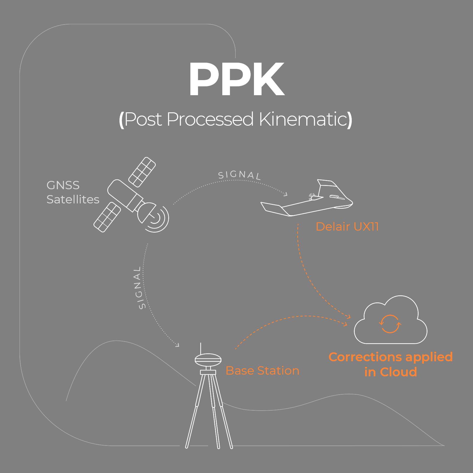
Post-Processed Kinematic (PPK)
Our professional mapping drone delivers the accuracy you need. The Delair UX11 is equipped with a dual-frequency GNSS sensor (L1, L2) and supports both GPS and GLONASS satellites. PPK can be activated at any time—without restrictions, on demand, or even retrospectively. The included Delair After Flight software supports PPK processing.
In which industries can you use Delair UX11?

Surveying and Mapping
Mining and Aggregates
Energy and Utilities
Security and Defense

Construction
Oil and Gas Industry
Key Applications
| Terrain Mapping & GIS |
| Surveying |
| Construction |
| Environmental Protection & Conservation |
| Surface Mining |
| Aggregates |
| Public Land Management |
| Linear Mapping |
Delair UX11 Package Contents
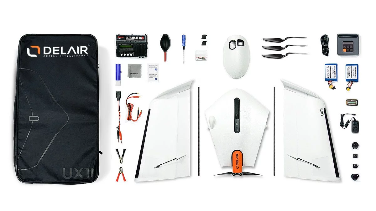
- ➤ Delair UX11 Drone
- ➤ Delair Link ground station with charger
- ➤ Batteries (2) and charger (1)
- ➤ Lightweight transport bag (1)
- ➤ Delair Flight Deck software (available on Google Play)
- ➤ Delair After Flight software
- ➤ 3G/4G connectivity – 2-year subscription, up to 40 flight hours per month
- ➤ Accessories and spare parts:
- ➤ Pitot tubes (2)
- ➤ Protective plate (1)
- ➤ Connecting rods (2)
- ➤ Propellers (3 pairs)
- ➤ Propeller screwdriver (1)
Delair UX11 Specifications
| SPECIFICATIONS | |
|---|---|
| Flight time | Up to 80 minutes |
| Weight (with payload) | 1.6 kg (3.5 lbs) |
| Wingspan | 1.2 m (47 inches) |
| Setup time | 5 minutes |
| Cruise speed | 54 km/h (34 mph) |
| Takeoff / Landing | Hand launch (30° angle) / Belly landing (30° angle) |
| Flight range | 53 km (33 miles) |
| Coverage area | 12 km² (300 acres) at 1.7 cm GSD, flying at 122 m (400 ft) |
| Certification | C6 EASA certified and ready for STS-02 flights and training |
| COMMUNICATION RANGE | |
| 3G/4G | Unlimited (within network coverage) |
| Delair Link (2.4 GHz radio) | 5 km (FCC) / 3 km (CE) |
| OPERATING CONDITIONS | |
| Weather conditions | Wind up to 45 km/h (28 mph), light rain |
| Max altitude (MSL) | Takeoff: 5,000 m (16,400 ft); Flight: 6,000 m (19,700 ft) |
| Landing accuracy | 5 m (16 ft) |
| Temperature range | -20 to 45°C (-4 to 113°F) |
| SENSORS | |
| Sensor type | Global shutter, distortion-free |
| Image resolution | 21.4 MP |
| Dynamic Range | 70 dB |
| HFOV / VFOV | 38° / 32° |
| In-Flight Configuration | Automatic or Manual (Brightness) |
| In-Flight Data Transmission | Real-time histogram, image quality assessment |
| TRANSPORT CASE | |
| Lightweight Transport Case | Dimensions: 79x43x35 cm (31x17x14 in), weight with accessories: 14 kg |