
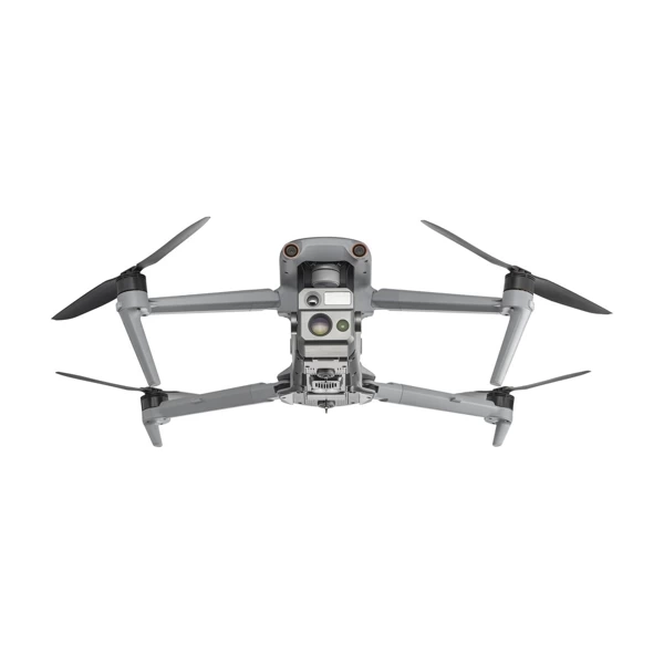
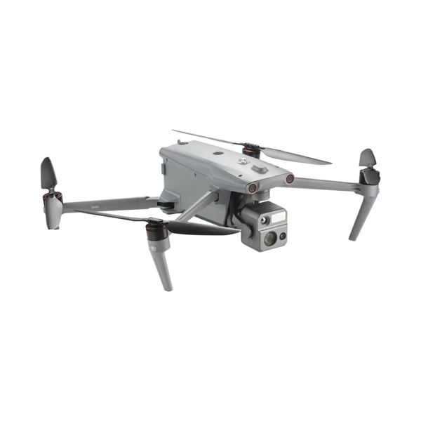
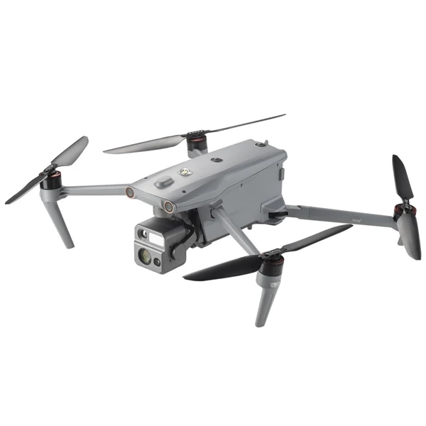
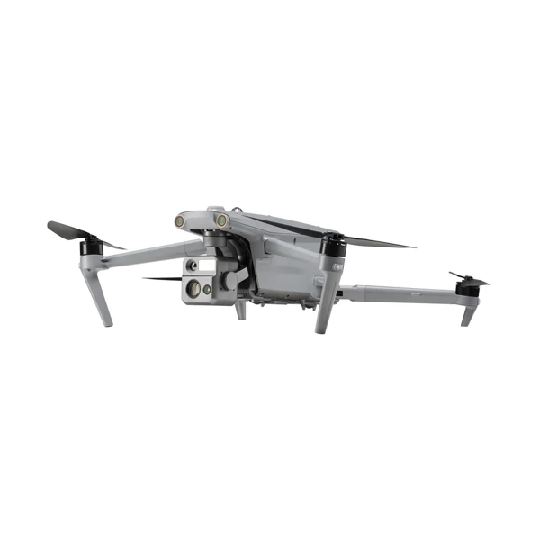
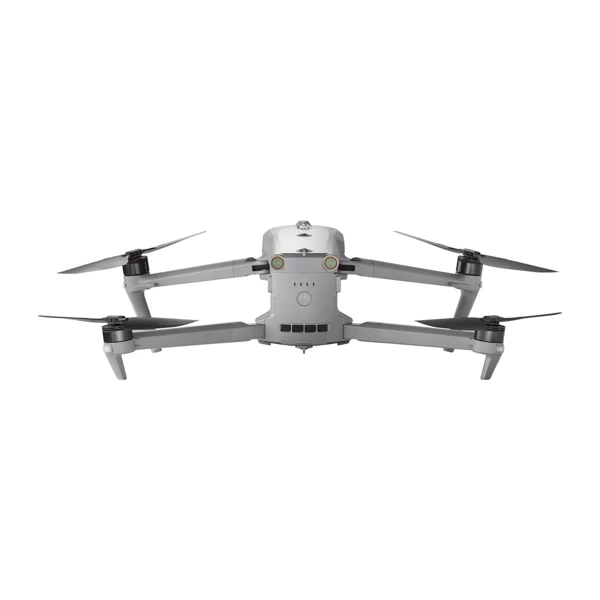
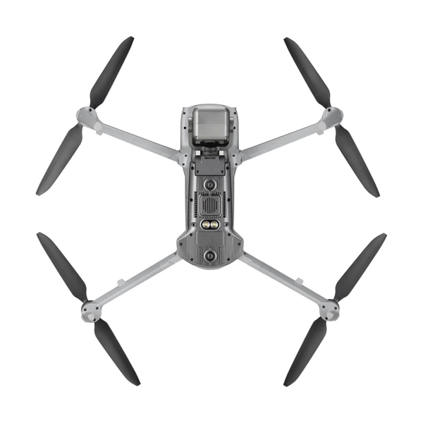

Autel EVO MAX 4N Standard Bundle

Autel EVO Max 4N - the leader in drone intelligence
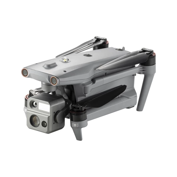
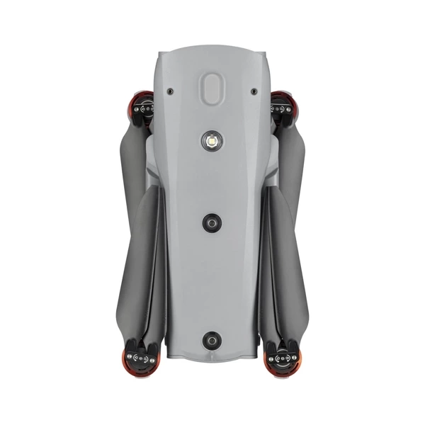
The Autel EVO Max 4N provides professional drone users with powerful technologies and advanced autonomy. The EVO Max 4N analyzes the environment to create real-time 3D flight paths used for obstacle avoidance. Advanced sensors enable flight in GPS-denied areas, and the new camera ensures excellent object identification and tracking. With its compact, weather-resistant design, the Autel EVO Max 4N is both portable and durable.

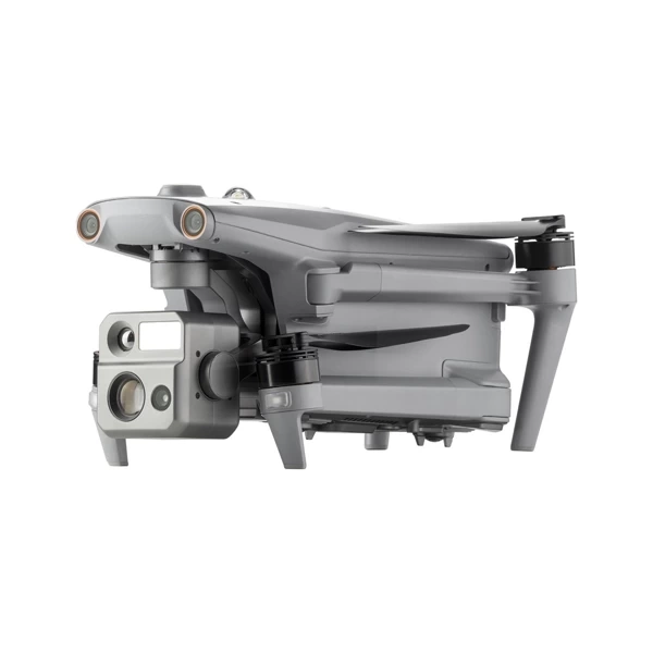
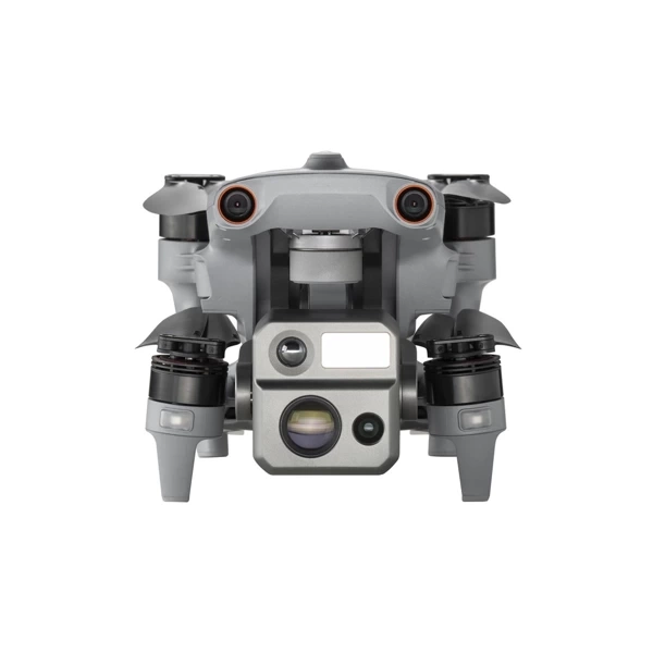
EVO Max 4N: Comprehensive Data Collection and Decision-Making Solution
The EVO Max 4N is an advanced hybrid sensor system that combines a starlight camera, wide-angle, thermal imaging, and a laser rangefinder, providing comprehensive data collection capabilities in any conditions.
Laser Rangefinder: Distance Accuracy
The EVO Max 4N laser rangefinder allows you to quickly obtain precise coordinates and object height from a distance of up to 1.2 km. A single touch is all it takes to instantly acquire the needed data.
640x512 Thermal Camera: High Resolution and 16x Digital Zoom
The EVO Max 4N system is equipped with a 640x512 thermal camera offering radiometric imaging at 30 frames per second and 16x digital zoom. This is the perfect tool for precise monitoring in low-visibility conditions.
Wide-Angle Camera with Moonlight 2.0 Algorithm: Excellent Quality in Low Light
Autel's Moonlight 2.0 algorithm enhances image processing, enabling clear and detailed photos even in poor lighting conditions. The EVO Max 4N supports 4K video at 30 frames per second and a maximum ISO of 64000. Moonlight mode reduces noise and enhances HDR, offering unparalleled image quality.
Starlight Camera: See Clearly in Any Conditions
The new starlight camera in the EVO Max 4N is designed for low-light operations, providing exceptional image clarity. This is an ideal solution for night operations and challenging lighting conditions.
The EVO Max 4N is a technologically advanced solution that meets the highest monitoring, security, and data collection standards in any situation. With a unique combination of cameras and a laser rangefinder, this sensor system is the perfect choice for professionals who need precise and reliable tools for work in various conditions.

Night Certification: Utilize the Starlight Lens for Night Operations and Precise Target Tracking
The new starlight lens in the EVO Max 4N allows for night scenario exploration and target tracking with remarkable accuracy. Thanks to advanced technology, every shot at night becomes exceptionally clear and detailed.

Moonlight 2.0 Algorithm: Enhanced Image Quality in Low Light
The Moonlight 2.0 algorithm significantly improves image processing quality, allowing for the capture of sharp and detailed images even in low-light conditions.
- 4K Video: Capture video in 4K resolution at 30 frames per second, with a maximum ISO of 64000, providing exceptional clarity even in challenging lighting conditions.
- Moonlight Mode: In photo mode, noise is reduced, and HDR is further enhanced, resulting in clear, detailed, and naturally looking images.

Advanced Thermal Imaging: EVO Max 4N with 640x512 High Resolution
The EVO Max 4N is equipped with a high-resolution 640x512 thermal camera that offers radiometric imaging and ensures precise monitoring in any conditions.
- Focal Length: 13 mm*/9.1 mm**
- Digital Zoom: 16x digital zoom allows for precise magnification and analysis of thermal details.
The EVO Max 4N is designed to work in the most challenging lighting conditions, both at night and in difficult thermal situations. This gives your operations precision and efficiency.

Precise Distance Measurement: Quickly Obtain Coordinates and Height Up to 1.2 km
Thanks to advanced EVO Max 4N technology, a single touch is all it takes to quickly and accurately obtain the coordinates and height of a selected target from up to 1.2 km away. This reliable tool provides precise real-time data, which is crucial during operations requiring the highest accuracy.

-
-
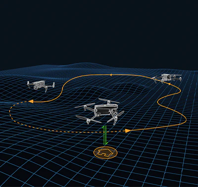
Autonomous Flight Path Search Autel's Autonomy Engine collects environmental data and plans 3D flight paths through complex environments such as mountains, forests, and buildings. Use cases include rapid 3D scene reconstruction, public safety protection, industrial inspections, and terrain surveying.
-
-
-
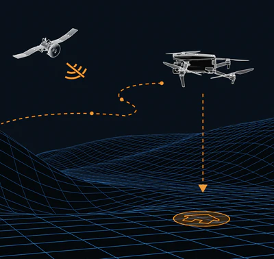
Non-GPS Navigation Advanced sensors allow the EVO Max 4N to navigate in challenging terrain, even without GPS access.
-
-
-
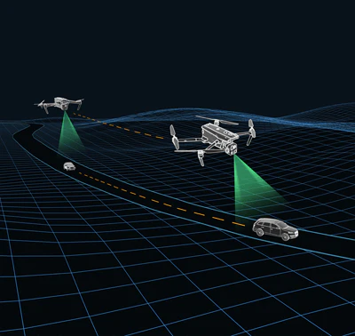
Accurate Object Identification and Tracking Based on Autel's AI recognition technology, the EVO Max 4N can automatically identify and lock onto various target types, such as heat sources, moving people, or vehicles, and track them even at high altitudes.
-
-
-
-
-
No Blind Spots
The Autel EVO Max 4N is the only commercial drone that combines a traditional binocular vision system with millimeter-wave radar technology. This enables the onboard Autel Autonomy Engine in the EVO Max 4N to perceive objects with an accuracy of up to 0.5 inches, eliminating blind spots and allowing operation in low light or rain.
*Obstacle avoidance performance varies depending on drone speed, lighting, and flight conditions and is not intended to replace pilot responsibility.
Anti-Jam, Anti-Interference
The Autel EVO Max 4N utilizes advanced flight control modules and algorithms specifically designed to counter RFI, EMI, and GPS spoofing. This allows the EVO Max 4N to fly confidently near power lines, critical structures, and in complex areas.

Platform Capabilities
The EVO Max 4N redefines portability with a powerful platform and an all-weather-resistant design. It is equipped with the following features and capabilities:
- 42 minutes maximum flight time
- IP43 protection rating
- Maximum wind resistance of 27 mph
- 23,000ft Service Ceiling
- 12.4-mile transmission range
*Takeoff and landing can withstand winds of up to 27 mph (12 m/s).

A-Mesh 1.0 - Mesh Network Technology
The EVO Max 4N features a new A-Mesh system, enabling autonomous drone-to-drone communication, connection, and cooperation for seamless corporate operations.
Strong Interference Protection
The EVO Max 4N can smoothly communicate with other nearby drones, unlike traditional chain-based structures. If a single drone fails or exits unexpectedly, the entire system will independently self-organize and continue to relay critical information.
Beyond Visual Line of Sight Operations
With A-Mesh, multiple nearby aircraft can act as relay points to significantly enhance BVLOS operations' effectiveness.
Fleet Control
Multiple drones can be autonomously controlled by a single pilot or group of pilots simultaneously with or without LTE coverage.
Extended Range
Communication nodes can be statically placed on hills or poles to provide full area coverage, or a drone swarm can provide mobile communication points to extend the entire group's range.

Autel SkyLink 3.0
The Autel EVO Max 4N SkyLink 3.0 system is equipped with 6 antennas, 4 frequency bands, AES-256 encryption*, and optional 4G integration* to provide users with the most advanced flight capabilities ever introduced in the EVO series.
- 12.4-mile image transmission range
- Real-time image quality 1080p/60fps
- Frequency bands 900MHz/2.4GHz/5.2GHz/5.8GHz**
- Latency <150ms
*This feature will be available in a future update.
**5.2GHz applies only to FCC, CE, and UKCA regions. The 900MHz band applies only to FCC regions.

Autel Enterprise App Platform
The Autel Enterprise App platform was built from the ground up with enterprise applications in mind, featuring a brand-new interface that ensures simple and efficient operation. Additional features and semi-autonomous modes maximize the EVO Max 4N's readiness and capabilities.

Smart Features
The EVO Max 4N is equipped with the following smart features tailored to the needs of commercial end users:
3D Map Planning.
Plan, create, and execute mission plans with 3D waypoints on a 3D map.
Mission Playback*.
Perform a manual or semi-autonomous mission or combine multiple missions into one. The EVO Max 4N will automatically record camera angles and replay the mission you just flew.
Quick Mission*
Temporary quick missions can be created while performing other missions, and multiple sub-missions can be stacked for increased flexibility.

Multiple Mission Types
The Enterprise App allows planning various autonomous and semi-autonomous missions for public safety, inspection, surveying, and other commercial applications.
Waypoint Missions
Users can add waypoints for flexible, unstructured flight paths.
Rectangular Mission
Supports automatic generation of a rectangular flight area with one click.
Automatic Mission (data generation and capture*)
Automatically create routes by adding boundary points of the region via points or importing KML files.

Terrain Follow*
Maintain a relatively constant altitude from the ground in the case of uneven or sloping terrain.
Oblique Photography
Automatically plan 5 groups of routes (1 ortho + 4 oblique) according to the flight area set by the user.
Spiral Mission*
Supports spiral flight search in a designated area for SAR.

Polygonal Mission
Support for automatic generation of polygonal flight areas with one click.
Vertical Scan*
Performs vertical measurements of building facades, excavation walls, and towers.
Corridor Mission*
Supports intuitive and efficient corridor mission planning for roads, rivers, pipelines, power lines, and other narrow, large-scale areas.
*This feature will be available in a future update.

Data Security
AES 128/256 encryption in storage, radio link, and network ensures operational security.
Privacy Protection
User data and aircraft information, including flight logs, locations, and account information, can only be physically accessed through the aircraft.
Encrypted Data Storage
Supports AES-256 encryption for photos, videos, and flight logs, all protected by a password.

Multi-Channel Projection Screen*
Supports simultaneous display of RGB, infrared, night vision, and wide-angle images.
AR Scene*
Geolocation data and other aircraft location information detected by ADS-B can be overlaid on the map in real-time, making it convenient for users to confirm the drone's location and avoid airborne risks.
*This feature will be available in a future update.

Autel SDK
The Autel SDK is open to the world, helping developers and partners reduce software and hardware development costs and jointly create a new industry ecosystem.
Mobile SDK
The Open UX SDK (iOS & Android) can directly invoke a ready-to-use interactive interface.
Payload SDK*
Unified interface standards support access to third-party mounts such as microphones and gas detectors.
Cloud SDK*
Enables remote live streaming and control of drones and Nests via third-party platforms or websites.

Applications
The Autel EVO Max 4N is designed for surveying and inspection, search and rescue, public safety, and many other commercial applications.

PACKAGE CONTENTS:
- Drone (battery, propellers, gimbal, gimbal cover, 64GB SD card)
- Charger + power cable
- Spare propeller (pair)
- Screwdriver
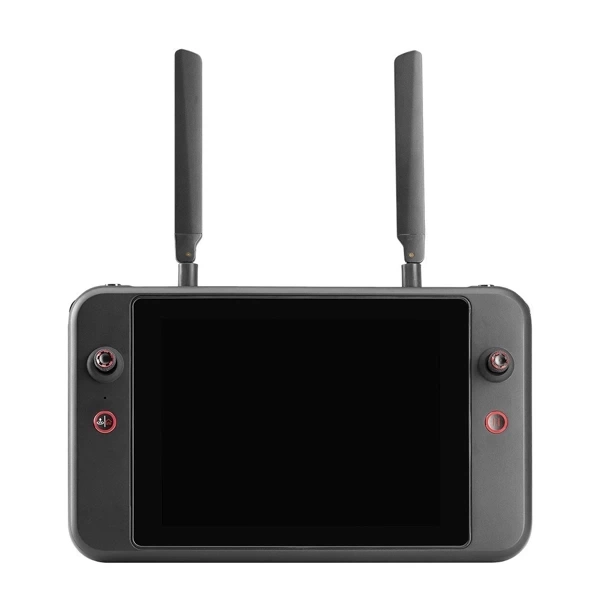
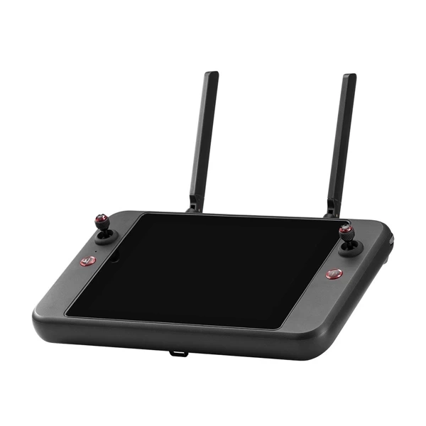
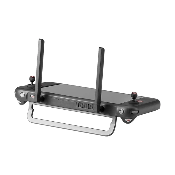
- Smart Controller V3 (with control sticks)
- Smart controller lanyard
- Smart controller cover
- Spare joystick for smart controller (pair)
- RC charger
- RC charging cable
- Data transfer cable
- Quick Start Guide
- Package contents document
- Durable case
SPECIFICATIONS:
Weight: 3.5 lbs (1600g with battery and gimbal included)
Max. Takeoff Weight: 4.41 lbs (1999 g)
Dimensions:
576x660x149 mm (unfolded, including propellers)
340x407x148 mm (folded, without propellers)
257x136x133 mm (folded, without propellers)
Diagonal Axis Distance: 1.52 ft (464mm)
Maximum Ascending Speed: 8m/s
Max. Descending Speed: 6 m/s
Max. Horizontal Speed (in still air near sea level): 23m/s
Maximum Service Ceiling Above Sea Level: 7000m (23000ft)
Maximum Flight Time (in still air): 42 min.
Max Hover Time (in still air): 38 minutes
Maximum Wind Resistance: 27mph*
*Takeoff and landing can withstand winds of up to 27 mph (12 m/s).
IP Protection Rating: IP43
Maximum Tilt Angle: 35°
Max. Angular Speed:
Pitch: 300°/s; Yaw: 120°/s
Operating Temperature: -4°F to 122°F (-20°C - 50°C)
Operating Frequency: 2.4G/5.2G*/5.8G/900MHz*
GNSS: GPS+Galileo+BeiDou+GLONASS
Transmitter Power (EIRP):
2.4GHz:<33dBm(FCC), <20dBm(CE/SRRC/MIC)
5.8GHz:<33dBm(FCC), <30dBm(SRRC), <14dBm(CE)
5.15-5.25GHz: < 23dBm(FCC/SRRC/MIC)
5.25-5.35GHz: <30dBm(FCC), <23dBm(SRRC/MIC)
Hover Accuracy:
Vertical:
±0.1 m (vision system enabled);
±0.3 m (GPS enabled);
±0.15 m (RTK enabled);
Horizontal:
±0.15 m (Vision System enabled);
±0.3 m (GPS enabled);
±0.1 m (RTK enabled);
STARLIGHT CAMERA
Sensor:
- Effective Pixels: 2.3M
Lens:
- Focal Length: 35 mm (equivalent 41.4 mm)
- Field of View: 52°
- Zoom Range: 1-8x, supports zoom with combination
ISO Range:
- Auto: ISO 100-ISO 450000
- Super-Sensitive Mode: Auto ISO 100-ISO 450000
Camera Modes: Single Shot (default)
Photo Format: JPG
Photo Resolution: 1920×1200
Video Format: MP4
Video Resolution: 20Mbps (1920×1200 P30)
HDR Video: Auto
Video Output: Super-Sensitive Mode: 1920×1200 P30
WIDE-ANGLE CAMERA
Sensor: 1/1.28 CMOS, Effective Pixels: 50M
Lens:
- DFOV: 85°
- Focal Length: 4.5 mm (equivalent: 23 mm)
- Aperture: f/1.9
- AF Motor: 8-wire SMA, PDAF focus
Exposure Compensation: ±3EV 0.3EV/step
ISO Range:
- Auto:
- Photo: ISO 100~ISO 6400
- Video: ISO 100~ISO 64000 (night mode: up to ISO 64000)
- Manual:
- Photo: ISO 100~ISO 12800
- Video: ISO 100~ISO 6400
Exposure Time:
- Photo: 8s ~ 1/8000s
- Video: 1s ~ 1/8000s
Maximum Video Resolution: 3840×2160
Photo Size: 8192x6144, 4096x3072
THERMAL CAMERA
Thermal Imaging: Uncalibrated VOx microbolometer
Thermal Sensor: Radiometric
Lens:
- DFOV: 64°
- Aperture: 13 mm
- Focus: f/1.2
Temperature Measurement Accuracy:
- 26.6~37.4 °F or reading ±3% (whichever is greater) at ambient temperature -4°F to 140°F
Video Resolution: 640x512
Photo Size: 640x512
Pixel Pitch: 12 µm
Temperature Measurement Method:
- Central, Spot, Rectangular Measurement
Temperature Measurement Range:
- -4°F to 302°F, 32°F to 1022°F (-20°C to 150°C, 0 to 550°C)
Temperature Alarm:
- High and low temperature alarm thresholds, coordinates, and temperature value reporting
LASER RANGEFINDER
Measurement Accuracy: ±3.3 ft (1 m)
Measurement Range: 3937 ft (1200 m)
GIMBAL
Mechanical Range:
Pan: -135° to 45°
Tilt: -45° to 45°
Roll: -45° to 45°
Control Range:
-90° to 30°
Stabilization System:
3-axis mechanical gimbal (pan, tilt, roll)
Maximum Control Speed (pitch): 200°/s
Angular Vibration Range: <0.005°
IMAGE TRANSMISSION
Operating Frequency:
2.4G/5.2G*/5.8G/900MHz*
*5.2GHz applies only to FCC, CE, and UKCA regions. 900MHz applies only to FCC regions.
Max Transmission Distance (unobstructed, no interference):
12.4 miles/20km (FCC), 4.9 miles/8km (CE)
Independent Network Connection: Autel Smart Controller V3
Transmitter Power (EIRP):
2.4GHz:<33dBm(FCC), <20dBm(CE/SRRC/MIC)
5.8GHz:<33dBm(FCC), <30dBm(SRRC), <14dBm(CE)
5.15-5.25GHz: < 23dBm(FCC/SRRC/MIC)
5.25-5.35GHz:<30dBm(FCC), <23dBm(SRRC/MIC)
AUTONOMY
Non-GPS Hover and Manual Flight:
Indoor: Horizontal error =1.18in (at least one-directional texture)
Outdoor:
Daytime: Within 1640ft (500m) flight height, horizontal error < 0.01*height
Night: Manual flight possible within 328ft (100m) flight height
Non-GPS Return-to-Home:
Within a flight height of 1640ft (500m), horizontal error of Return-to-Home point < 11.81in.
Automatic Obstacle Rerouting:
High-Speed Obstacle Rerouting: Flight speed up to 45mph (20m/s), when Min. safe distance from obstacle is 4.9ft (1.5m)
Precision Obstacle Rerouting: Flight speed can reach 6.7mph (3m/s) when the minimum safe distance from the obstacle is 1.64ft (0.5m).
Multiple Target Recognition and Tracking:
Target Identification Types: People, Vehicles, Boats
Number of Detected Targets: 64
Comprehensive Recognition Accuracy: > 85%
MILLIMETER-WAVE RADAR SYSTEM
Frequency: 60Ghz~64Ghz*
*Please fly safely and consult local laws and regulations.
Size: 1.5x0.55x0.08 in (38x14x2mm) (LxWxH)
Weight: 0.07oz (2g)
EIRP: 18dBm
Sensing Range:
Upward: 5.9~787.4in (0.15~20m)
Downward: 3.9~4724.4in(0.1~120m)
Forward/Backward (Standard/Comfortable): 0.82~98.43ft (0.25~30m)
Forward/Backward (Standard/Comfortable): 0.82~98.43ft (0.25~30m)
FOV:
Horizontal: (6dB): ±60°, Vertical (6dB): ±30°
Speed Measurement Range: ±134mph (60m/s)
Speed Measurement Accuracy: ≤1%.
Max. Number of Tracked Targets: 32
OPTICAL SENSOR SYSTEM
Obstacle Detection Range:
Forward/Upward/Downward/Backward/Sideward: 0.2~50m
FOV:
Forward/Backward/Sideward: 60°(H), 80°(V)
Upward/Downward: 360°(H), 190°(V)
AUTEL SMART CONTROLLER V3
Screen: 7.9 inches, max brightness 2000 nits, resolution 2048*1536
External Battery:
Capacity: 5800mAh
Voltage: 11.55V
Battery Type: Li-on
Energy: 67Wh
Runtime: 120min
Intelligent Lithium-Ion Battery
Runtime:
3 hours (Max brightness)
4.5 hours (50% brightness)
Max Transmission Distance (with interference):
12.4 miles/20km (FCC), 4.9 miles/8km (CE)
IP Protection Rating: IP43
Storage: 128G
GNSS: GPS+GLONASS+Galileo+Beidou+NavIC+QZSS
Operating Temperature:
-4°F to 104°F (-20°C to 40°C)
Wi-Fi Protocol:
Wi-Fi Direct, Wi-Fi Display,
802.11a/b/g/n/ac
Supports 2 x 2 MIMO Wi-Fi
Operating Frequency:
2.400 - 2.4835 GHz;
5.150 - 5.250GHz;
5.725 ? 5.850 GHz
Transmitter Power (EIRP):
2.400 - 2.4835 GHz
FCC/CE:=20dBm
5.150 - 5.250GHz
FCC:=17dBm
5.725 ? 5.850 GHz
FCC:=17dBm
CE:=14dBm
FLIGHT BATTERY
Capacity: 8070mAh
Voltage: 14.88V
Battery Type: LiPo 4S
Energy: 120wh
Net Weight: 1.15 lbs (520g)
Charging Temperature:
41°F to 113°F (5°C to 45°C)
When the temperature is below 10°C (50°F), the self-heating function will automatically turn on. Charging at low temperatures may shorten battery life.
Hot Swap: Supported