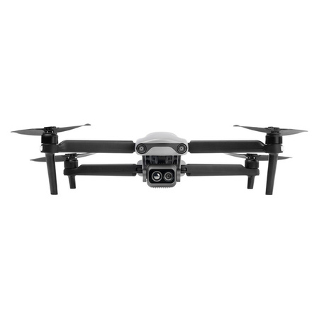
Autel Robotics EVO Lite 640T Enterprise
The EVO Lite Enterprise series by Autel Robotics offers numerous advantages, such as a lightweight and portable design, rapid deployment, and simple control for industrial applications. The AI target recognition feature allows the drone to easily identify and map various target objects automatically. Three-way binocular vision obstacle avoidance ensures a safe flying experience.
The EVO Lite 640T Enterprise features a dual gimbal system, with the visible-light camera delivering clear and detailed images, while the thermal imaging camera supports decision-making during operations. Combined with the Autel Enterprise professional flight software, it offers easy operation, intuitive interaction, flexible single-operator deployment, and efficient application in scenarios like public safety and emergency rescue.
Main Features
- Lightweight and Portable
- 640*512 Infrared Thermal Imaging
- 6K Resolution
- 12km Video Transmission Range
- 40-Minute Flight Endurance
- Three-Way Binocular Vision Obstacle Avoidance
- AI Target Recognition and Positioning
- Simple Control with Smart Controller SE V2
Lightweight and Portable
The EVO Lite Enterprise drones weigh only 866 grams and have folded dimensions of 210*123*95mm, making them easy to carry in a backpack. With simple operation, they are ideal for efficient execution of missions by a single operator.

Autel Enterprise App
Autel Enterprise is a professional flight mission software designed for industrial applications by Autel Robotics. It features an optimized interface for simple and efficient operation, an editable toolbar for intuitive use, and integrates intelligent and professional functions to fully utilize the industrial value of the EVO Lite Enterprise series.

Split-Screen Display: Visible light, infrared, or map supports dual-channel simultaneous output on the screen, providing comprehensive information through comparison.

Customizable Toolbar: Customize the toolbar in the app for quick access to frequently used functions, meeting personalized user needs.

Offline Maps: Solves the problem of map loading failures in no-network or weak-network environments by supporting offline maps, helping in precise flight positioning.

AI Target Recognition and Positioning
Using wide-angle or infrared lenses combined with intelligent AI algorithms and a self-learning system, the drone can automatically recognize and locate targets, such as people, cars, and boats, projecting their positions on the map.

EVO Lite 640T Enterprise Dual Gimbal
Equipped with a dual gimbal, the wide-angle visible-light camera offers a broad field of view with vivid high-definition images, while the thermal imaging camera integrates high-resolution algorithms, providing clear and detailed thermal source identification.

Thermal Imaging Camera
640*512 resolution // 9.1 mm focal length // 16x digital zoom
Temperature measurement range: -20°C to 150°C / 0°C to 550°C
Temperature accuracy: ±3°C or ±3% of reading (whichever is greater)
Visible Light Camera
1/2 inch CMOS // 48 million pixels // F2.8 aperture // 16x digital zoom
Maximum photo size 8000*6000
Maximum video resolution 4K 30P
High-Definition Video Transmission
Equipped with Autel SkyLink image transmission technology for a dual-signal, dual-reception system, enhanced anti-interference capability, and transmission range of up to 12 kilometers. It supports 2.4GHz/5.2GHz/5.8GHz adaptive frequency hopping, automatically selecting the best channel based on electromagnetic interference, providing strong anti-interference capability, and 1080P/30FPS real-time image transmission quality with less than 200 milliseconds latency.

Visual Perception System
The drone is equipped with wide-angle vision sensors at the front, back, and bottom, ensuring reliable flight safety.

Flight Performance
Small but mighty. The exceptional flight performance of the EVO Lite Enterprise drones effortlessly handles various challenges across multiple scenarios, significantly enhancing the efficiency of single-person mission flights.
40 minutes endurance
18 meters per second maximum horizontal flight speed
3000 meters maximum takeoff altitude

SDK Ecosystem
The open Mobile SDK provides efficient, versatile, and easy-to-use control and service interfaces, enhancing development efficiency and enabling the creation of custom solution scenarios.
Data Security with Multiple Protections
Privacy Protection: Flight logs, locations, and other user privacy data require user consent to upload.
Encrypted Storage: Supports AES encryption for photos, videos, and flight logs, requiring a password for access.
Live Video Streaming: Supports RTMP and GB28181* protocols for live streaming, allowing remote real-time viewing and analysis. *The GB28181 live streaming protocol feature is planned for future updates.
What's in the Box:
- Aircraft x 1
- Remote controller x 1
- Battery charger x 1
- USB-C to USB-A data cable
- User documentation
| Description | |
|---|---|
| Construction | |
| Model | Drone |
| Product Color | Gray |
| Number of Rotors | 4 rotors |
| Number of Propeller Blades | 2 |
| Wheelbase | 36.8 cm |
| Number of Cameras | 2 |
| Thermal Camera | Yes |
| Features | |
| Maximum Speed | 18 m/s |
| Maximum Operating Range | 12,000 m |
| Frequency Band | 2.4 GHz/5.2 GHz/5.8 GHz/900 MHz |
| Maximum Flight Time | 40 minutes |
| Number of Axes | 3 |
| Maximum Takeoff Altitude | 3,000 m |
| Maximum Wind Resistance (Takeoff and Landing) | 12 m/s |
| GPS | Yes |
| GLONASS | Yes |
| Galileo | Yes |
| Sensor System Type | Omnidirectional |
| Ultrasonic Sensor | Yes |
| Camera | |
| Megapixels | 48 MP |
| Supported Video Modes | 1080p, 4K |
| Video Transmission | Yes |
| Maximum Frames Per Second | 30 fps |
| Live View | Yes |
| Photo Resolution | 8000 x 6000 pixels |
| Sensor | CMOS 1/2" |
| Fixed Focal Length | 9.1 mm |
| Aperture | F2.8 |


